Course: User workshop and training on fire monitoring products (2020) | EUMETSAT

  • Welcome to the User Workshop and Training on Fire Monitoring


    An online event through interactive data discovery and user practices on state-of-the-art operational datasets for detection of fire, related emissions and impacts

    Jointly organized by EUMETSAT, CAMS-ECMWFAC SAFLSA SAF

    with support from Copernicus

      Data Discovery Week 
              11-15 May - Daily webinars with experts on datasets with interactive handling (open access).

      Data Discovery Resources
              A collection of videos and presentations of datasets designed for the training workshop, but open to all.     

      Workshop 
              18-19 May - A two day workshop on practical workflows and user needs (for registered participants only).


  • Open all

    Close all

  • Instructions: Clicking on the section name will show / hide the section.

  • 1

    In this section we invite you to explore on your own a collection of videos on measuring composition from satellite, biomass burning and aerosol models. The videos were part of a recent Copernicus Massive Open Online Course (MOOC), a collaborative effort of EUMETSAT and CAMS-ECMWF. 

    The complete series of the MOOC is available at: www.atmosphericmooc.org.

  • 2
    Not available unless: You belong to AC Workshop participants
  • 3

    We invite you to a week of daily online webinars. Consult the programme proposed, mark your calendar and join us for the live session every day at 10:00 CET to connect with the experts. Each live session will consist of:

    1. Presentation of data.

    2. Dos and don'ts with datasets.

    3. Where to access data and on-line discovery.

    4. Introduction to self-paced activity.

    The instructor of the morning session will be available each day from 15:00 to 16:00 CET to answer your questions on slido (www.slido.com), join the event with the event code: #fireworkshop.

    All sessions will be recorded and made available on this course page.

    Agenda of the webinars:

  • 4
    Not available unless: You belong to AC Workshop participants
  • 5

    The main objectives of EUMETSAT Atmospheric Composition SAF (AC SAF) is to process, archive, validate and disseminate atmospheric composition products from GOME-2 and IASI instruments onboard EUMETSAT Metop-A, -B, and -C satellites. These products include column-integrated concentrations of different trace gases such as nitrogen dioxide (NO2), ozone (O3) and sulphur dioxide (SO2), carbon monoxide (CO) UV-radiation, aerosol index as well as ozone profiles.  Important applications of AC SAF data include monitoring global air quality and UV-radiation reaching the Earth's surface. This section describes the observations from GOME-2 instrument relevant for this training and how to access the data. IASI  observations are described in a separate section. 

    • From this section you can find basic information on aerosol absorbing index (AAI), and learn which kind of studies you can use the data for. 

    • This section gives a short overview on GOME-2  Offline aerosol data. 

    • In this section you will learn how to register as a user to the FMI and DLR ATMOS data services. This is needed in order to download the aerosol (FMI) and trace gas (DLR)  data. 

    • In this section you will learn how you can access the data via DLR ATMOS and FMI data services. 

  • 6

    This section provides you with an overview of Sentinel 5P - how you may access the data. In this course we will focus on Absorbing Aerosol Index (AAI) and CO TROPOMI S5P data. However, also other TROPOMI parameters, such as NO2 and HCHO can be accessed  and visualised using the instructions below. 


    • In this section you can find basic information on TROPOMI atmospheric observations relevant for fire monitoring.

    • In this section you can find basic information on Google Earth Engine and TROPOMI S5P data. 

    • In this section you will learn how to register as a user to Google Earth Engine. This is needed in order to use the satellite data.

  • 7

    The Copernicus Atmosphere Monitoring Service (CAMS) provides consistent and quality-controlled information related to air pollution and health, solar energy, greenhouse gases and climate forcing, everywhere in the world. It is implemented by ECMWF on behalf the European Commissions and is one of six Copernicus data services. The principal CAMS datsets are global forecasts and analyses of reactive gases (O3, CO, NO2, SO2, HCHO), greenhouse gases (CO2, CH4) and aerosol optical depth. In addition to the atmospheric composition products, CAMS also provides near-real-time daily and hourly data on global fire emissions and inventories of anthropogenic and biogenic emissions. In this section you will find out how to access and download CAMS data. 


  • 8

    IASI is an infrared Fourier transform spectrometer developed jointly by CNES (the French spatial agency) with support of the scientific community, and by EUMETSAT. IASI is mounted on-board the European polar-orbiting MetOp satellite with the primary objective to improve numerical weather predictions, by measuring tropospheric temperature and humidity with high horizontal resolution and sampling. IASI also contributes greatly to atmospheric composition measurements for climate and chemistry applications, providing observations both day and night.  IASI retrieves observations of several trace gases and aerosols, for this course primarily carbon monoxide (CO) will be used. Currently, from IASI observations CO and sulphur dioxide (SO2) are part of AC SAF product family. In this section you will find out how to access IASI CO data.

  • 9

    The European Centre for Medium-Range Weather Forecasts (ECMWF) produces daily fire danger forecasts and reanalysis products from the Global ECMWF Fire Forecast (GEFF) model. Reanalysis (and soon seasonal forecasts) is available through the Copernicus Climate Data Store (CDS) while the medium-range real-time forecast is available through the EFFIS and GWIS platforms, which give access to timely fire danger information at a pan-European and global scale, respectively. Thirty-eight local and national authorities across Europe are part of the EFFIS network and have been relying on GEFF outputs for the early identification of regions prone to fire events as a result of persistent drought conditions.

    • GEFF-reanalysis provides historical records of global fire danger conditions from 1980 to the present day and it is made of four types of products: (i) deterministic model outputs (called simply 'reanalysis' on the CDS), (ii) probabilistic model outputs (made of 10 ensemble members), (iii) ensemble mean and (iv) ensemble spread. It is updated as soon as new ERA-5 data becomes available (~2 months behind real-time). 
    • GEFF-realtime provides real-time high-resolution deterministic (~9 Km) and lower-resolution probabilistic (~18Km) fire danger forecasts up to 15 days ahead using weather forcings from the latest model cycle of the ECMWF’s Integrated Forecasting System (IFS). The real-time dataset is updated every day with a new set of forecasts. Forecast data can be requested to EFFIS using an online form.

    These products have been developed as part of the EU-funded Copernicus Emergency Management Services (CEMS) and complement other Copernicus products related to fire, such as the biomass-burning emissions made available by the Copernicus Atmosphere Monitoring Service (CAMS).  The development of the GEFF modelling system was funded through a third-party agreement with the European Commission’s Joint Research Centre (JRC). 

    GEFF produces fire danger indices based on the Canadian Fire Weather index as well as the US and Australian fire danger models. GEFF datasets are under the Copernicus license, which provides users with free, full and open access to environmental data.

    For more information, please refer to the documentation on the CDS and on the EFFIS website.


    DAY_10.png

    Figure 5.1  - Example fire danger forecast at day 10 (classified Fire Weather Index) in the Iberian Peninsula


    Software tools

    GEFF MODEL SOURCE CODE
    https://git.ecmwf.int/projects/CEMSF/repos/geff/browse

    DATA PROCESSING


    References

    Journal papers

    • Vitolo, C., Di Giuseppe, F., Krzeminski, B. and San-Miguel-Ayanz, J., 2019. A 1980–2018 global fire danger re-analysis dataset for the Canadian Fire Weather Indices. Scientific data, 6, p.190032.

    • Vitolo, Claudia, Francesca Di Giuseppe, and Mirko D’Andrea. Caliver: An r package for calibration and verification of forest fire gridded model outputs. PLOS ONE, 13(1):1–18, 01 2018

    • Di Giuseppe, F., Pappenberger, F., Wetterhall, F., Krzeminski, B., Camia, A., Libertá, G. and San Miguel, J., 2016. The potential predictability of fire danger provided by numerical weather prediction. Journal of Applied Meteorology and Climatology, 55(11), pp.2469-2491.

    Newsletter articles

  • 10

    The Eumetsat LSA SAF (Land Surface Analysis Application Facility) is generating products from MSG and Metop satellites, allowing  to characterize and to monitor land surfaces. The data is available in Near Real Time (NRT) and  Climate Data Records for some products are also available, enabling homogeneous time series analysis of several parameters. LSA SAF products are produced since 2004, at different time frequencies: from 15 min, for the case of MSG derived products, to daily and ten daily, for Metop based products. 

    From the set of products produced by the LSA SAF, the vegetation products, such as NDVI and fAPAR enable to characterize the vegetation conditions. 

    The ENDVI (EPS NDVI)  are near-global, 10-daily composite images which are synthesized from the "best available" observations registered in the course of every "dekad" by the orbiting earth observation system Metop-AVHRR.

    Fraction of Absorbed Photosynthetically Active Radiation (FAPAR) defines the fraction of PAR (400-700 nm) absorbed by the green parts of the canopy, and thus expresses the canopy's energy absorption capacity. FAPAR depends both on canopy structure, leaf and soil optical properties and irradiance conditions. FAPAR has been recognized as one of the fundamental terrestrial state variables in the context of the global change sciences (Steering Committee for GCOS, 2003; Gobron et al., 2006). It is a key variable in models assessing vegetation primary productivity and, more generally, in carbon cycle models implementing up-to-date land surfaces process schemes. Besides, FAPAR it is an indicator of the health of vegetation. FAPAR is generally well correlated with the LAI, the more for healthy fully developed vegetation canopies.


    Many wild fires are anticipated by extreme warm conditions. Maps of Land Surface Temperature allows to evaluate the extent of regions affected by very high temperatures. 

    The EDLST (EPS Daily Land Surface Temperature) provides a day-time and nigh-time retrievals of LST based on clear-sky measurements from the Advanced Very High Resolution Radiometer (AVHRR) on-board EUMETSAT polar system satellites, the Metop series.


    Fires location and intensity can be followed with the LSA SAF Fire Radiative Power (FRP) product, base on MSG observations. 

    The FRP product records information on the location, timing and fire radiative power (MWatts) output of landscape fires detected every 15 minutes across the full Meteosat disk at the native spatial resolution of the SEVIRI sensor.  Measuring this FRP and integrating it over the lifetime of a fire provides an estimate of the total Fire Radiative Energy (FRE) released, which for landscape fires should be proportional to the total amount of biomass burned.


    • To have access to LSA SAF data users must be registered and need to be logged in before an actual order can be set.


    • This sections presents more details about NDVI product

       ENDVI10 is available as a Climate Data Record (LSA-453) starting in March 2007 and an Interim Climate Data Record (LSA-410) performing continuous updates in Near Real Time of LSA-453. In both cases, ENDVI10 consists of composites representing a Normalized Difference Vegetation Index and are distributed together with a set of ancillary dataset layers (surface reflectances, sun and view angles, quality indicators).

    • FAPAR accounts for the active radiation absorbed by the canopy in the range of 400-700 nm, and therefore constitutes an indicator of the health and thereby productivity of vegetation.  It is thus suitable to quantify CO2 uptake by plants and the water release through evapotranspiration.

    • EDLST is the EPS Daily Land Surface Temperature, the radiative skin temperature over land measured by the clear-sky measurements from the Advanced Very High Resolution Radiometer (AVHRR) on-board EUMETSAT polar system satellites, the Metop series. It is availlable as daytime and nigh-time composites on a daily basis. 

    • The Meteosat SEVIRI Fire Radiative Power (FRP) products generated at the LSA SAF identify pixels containing fires that are actively burning  (so-called ‘fire pixels’) at the time of a SEVIRI observation, and provide an estimate of the Fires Radiative Power (FRP) output, together with its uncertainty.

  • 11

    In addition to its core marine and continental objectives, the Copernicus Sea and Land Surface Temperature Radiometer (SLSTR), onboard the Sentinel-3 A and B satellites, detects and monitors the immediate threats of any 'burning' events over an area size of 1 km2. Commonly gathered under the term of hotspots, these are not only fires over continents, but also flames from persistent land and ocean gas flares, and active erupting volcanoes.

    The Copernicus Sentinel-3 (S3) Near Real Time (NRT) FRP product, implemented by EUMETSAT, monitors in a short time the location and associated threat (i.e. total radiative power) of all land and ocean hotspots detectable on our planet. It is applicable to agricultural burning, wildfires, deforestation, tropical peatland fires, industrial gas flares, and volcanoes, all emit radiative signatures with a high seasonal and geographical variability.


    Sentinel-3 A SLSTR - NRT FRP MWIR [MW] - 05.12.2019 (night-time)

    The EUMETSAT deployment is based on the NRT FRP v2.0 processor. The current version of the NRT S3 FRP product is considered as 'preliminary operational'. It is mainly applicable during nighttime. EUMETSAT is responsible for the generation and quality of the Sentinel-3 NRT FRP product, as well as its long-term validation and improvements, acting on behalf of the European Commission (EC).

    The spectral wavelength at which the heating signal is maximal depends on the hot-spot temperature. Indeed, vegetation fire signals peak in the Medium Wave InfraRed (MWIR), between 3 and 5 µm, while hotter bodies, like industrial gas flares, may exhibit a higher signal in the ShortWave InfraRed (SWIR), between 1.5 and 2.3 µm. Consequently, two FRP techniques are employed: one based on the Medium Wave InfraRed (MWIR) channels, at 3.7 um, one based on the Short Wave InfraRed (SWIR).


    Sentinel-3 A SLSTR - NRT FRP SWIR [MW] - 26.04.2020 (night-time) - Industry gas flares in Persian Gulf


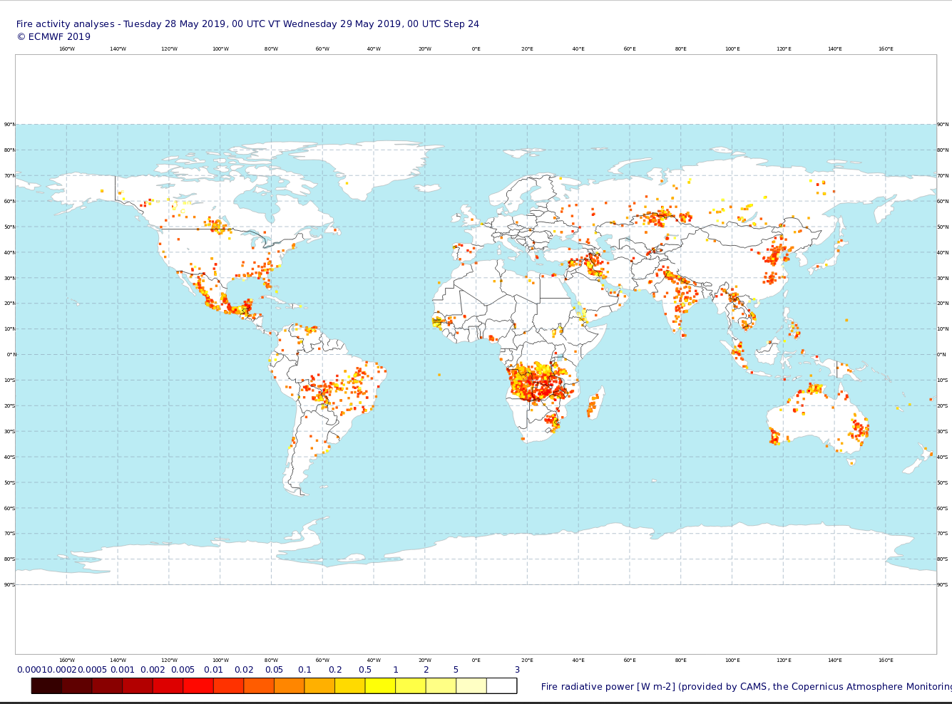
    One of the key users of this product is the Copernicus Atmosphere Monitoring Service (CAMS), who is responsible for tracking the intensity and emissions of wildfires around the world. EUMETSAT and CAMS have a long-standing cooperation, with EUMETSAT having developed an operational Copernicus data stream to CAMS and providing its satellite data and products in order for them to provide accurate and timely air-quality forecasts across the globe.

    CAMS will assimilate the Sentinel-3 NRT FRP product, into their own air quality-forecasting model, the data from which gets broadcast via Euronews and CNN International, in order to clearly show society at large how air quality might impact people’s day-to-day lives, so that they can make decisions on their exposure to pollution more easily. CAMS, implemented by the European Centre for Medium-Range Weather Forecasts (ECMWF) on behalf of the European Commission, will use its Global Fire Assimilation System (GFAS) to assimilate the NRT Copernicus S3 FRP product, in addition to currently assimilated satellite FRP products, in order to provide global biomass burning smoke emissions in a timely and effective manner. Currently, GFAS assimilates FRP from MODIS space-borne sensors, from both Terra (morning) and Aqua (afternoon) satellites. Both have been operated beyond their nominal lifetime. Hence, GFAS is currently under preparation to be able to ingest the NRT S3 FRP product soon. In the future, NRT S3 FRP, combined with GFAS, will likely be the only source of global information for fires and hotspots in the early morning and evening.