Data processing and file formats
Within this book you will find two chapters. The first covers the processing that takes place to generate the data that is ultimately received by users of the CMDS. The second chapter goes in to the format of these data files, and the information that can be extracted from them.
3. Data formats and processing methodology: SRAL
Data levels
Within altimetry remote sensing there are a series of levels that are used to define the amount of processing that has been performed to provide a given dataset:
-
Level-0 is the raw telemetered data.
-
Level-1B is the Level-0 data corrected for instrumental and geometrical effects. The main function of the Level-1 processing chain is to calculate the tracker range, the sigma0 scaling factor and the Level-1 waveforms, applying instrumental corrections to all of them.The Level-1 processing chain outputs three types of products: Level-1A , Level-1B-s and Level-1B products.
-
Level-2 is the Level-1 data corrected for geophysical effects. The first function of the Level-2 processing chain is to apply different retracking algorithms to the Level-1 waveforms to calculate the final altimeter range, backscatter coefficient, wind speed over ocean and SWH. There are different types of re-tracking algorithms according to the type of waveforms re-tracked (ocean, ice, sea-ice).
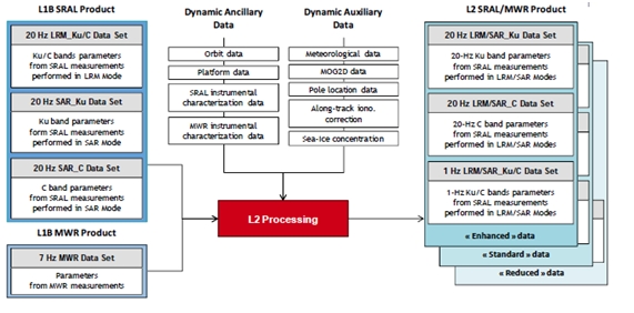
Figure 3.1; Level 2 processing stages for altimetry.
Processing Methodology
Level 0
The Level-0 product is an output from Level-0 processing and is an internal product only. The satellite sends all data measured to the ground stations in the form of Instrument Source Packets (ISP). The data in ISPs are categorised and packaged according to their type:
- TM_ACQ: telemetry packets generated during acquisition mode
- TM_CAL1: telemetry packets generated during CAL1 calibration mode
- TM_CAL2: telemetry packets generated during CAL2 calibration mode
- TM_ECHO_LRM: telemetry packets generated during LRM tracking mode
- TM_ECHO_SAR: telemetry packets generated during SAR tracking mode.
Level 1
The Level-1 calibration chain computes all calibration corrections. One part of these calibration corrections is characterised on the ground and one part is measured in flight. There are three types of calibrations:
- calibration due to internal calibration of the instrument (CAL1)
- calibration due to the gain profile range window (CAL2)
- calibration due to the calibration of the Automatic Gain Control (AGC) correction tables.
These calibration corrections are applied in the Level-1 measurement chains. There are two types of Level-1 processing measurement chains: one to process LRM and SAR-C band data and another to process SAR-Ku band data.
The main processing steps of the LRM and SAR-C Level-1 measurement chains are:
- Determine surface type.
- Correct tracker ranges for USO frequency drift.
- Compute internal path correction.
- Correct the AGC for instrumental errors.
- Compute Sigma0 scaling factor.
- Compute Doppler correction.
- Correct waveforms by CAL2.
The main processing steps of the SAR-Ku Level-1 measurement chain are:
- Determine surface type.
- Correct tracker ranges for USO frequency drift.
- Compute internal path correction.
- Correct the AGC for instrumental errors.
- Correct waveforms by CAL1 and CAL2.
- Compute surface locations.
- Apply Doppler correction.
- Apply slant range correction.
- Align the waveforms.
- Perform the Doppler beams stack multi-looking.
- Compute Sigma0 scaling factor.
Level 2
The first function of the Level-2 processing chain is to apply different re-tracking algorithms to Level-1 waveforms to calculate the final altimeter range, backscatter coefficient, wind speed over ocean and SWH. There are different types of re-tracking algorithms according to the type of waveforms re-tracked (ocean, ice, sea-ice). The second function of the Level-2 processing chain is to compute and apply all geophysical corrections to the measurements. Examples of geophysical correction algorithms are the tides or the reference surface used (e.g. the geoid).
There are three types of algorithms in the Level-2 processing chain:
- algorithms computing time-derived geophysical/environmental parameters
- algorithms computing retracking and computing physical parameters
- algorithms performing altimeter/radiometer geophysical processing.
Computing time-derived geophysical parameters involves:
- re-computing altitude, orbital altitude rate, location and Doppler correction, accounting for updated orbit data
- computing ionospheric corrections
- computing non-equilibrium and equilibrium ocean tide heights, tidal loading, solid earth tide height, equilibrium long period ocean tide height and pole tide height (using pole locations)
- computing the height of the mean sea surface above the reference ellipsoid
- computing the mean dynamic topography, the height of the geoid and the ocean depth/land elevation.
Performing retracking and computing physical parameters (LRM mode) involves:
- performing ocean re-tracking to waveforms, estimating waveform altimetric parameters such as epoch, composite sigma, amplitude or square of the mis-pointing angle
- computing 20 Hz altimeter range and backscatter coefficient
- computing 1 Hz estimates of the altimeter range, composite sigma, backscatter coefficients and square of the off-nadir angle (Ku-band only)
- computing 1 Hz physical parameters (SWH and modelled corrections for both bands) and correcting 1 Hz physical parameters.
Performing retracking and computing physical parameters (SAR mode) involves:
- discriminating echoes (ocean/lead, sea-ice, ice sheet margin or ocean/coastal)
- performing retracking (ocean/lead, sea-ice, ice sheet margin or ocean/coastal)
- computing physical parameters
- merging snow depth (ocean/lead and sea-ice only)
- performing a short-arc, along track ocean interpolation (ocean/lead and sea-ice only)
- estimating freeboards (ocean/lead and sea-ice only)
- performing a latitude limit check (ocean/lead and sea-ice only)
- performing modified slope correction (ice sheet margin and ocean/coastal only).
Level-2 altimeter/radiometer geophysical processing involves:
- inputting and checking Level-1 MWR products
- computing and correcting physical parameters according to platform data
- interpolating MWR data and computing MWR geophysical parameters
- computing altimeter wind speed and rain/ice flags
- computing wind, tropospheric corrections and inverted barometer according to meteorological data
- computing HF fluctuations of the sea surface topography
- computing sea state bias
- computing dual frequency ionospheric corrections
- building and checking Level-2 SRAL/MWR products.
The following products are generated at the levels described above;
Level-1A
This product contains the geo-located bursts of echoes with all calibrations applied
Level-1BS
Level-1B-S products contain fully SAR-processed and calibrated High Resolution complex echoes arranged in stacks after saint range correction and prior to echo multi-look
Level-1B
Level-1B products contain geo-located and fully calibrated multi-looked High Resolution power echoes
Level-2
A Level-2 SRAL/MWR complete product contains three files in netCDF format:
-
one "reduced" (Red) data file, containing a subset of the main 1 Hz Ku band parameters
-
one "standard" (Std) data file containing the standard 1 Hz and 20 Hz Ku and C-band parameters
-
one "enhanced" (Enh) data file containing the standard 1 Hz and 20 Hz Ku and C-band parameters, the waveforms and the associated parameters necessary to reprocess the data (at least in LRM mode).
File Names
The SRAL/MWR Level-2 product file name is defined according to the following convention:
MMM_SS_L_TTTTTT_yyyymmddThhmmss_YYYYMMDDTHHMMSS__YYYYMMDDTHHMMSS_<instance ID>_GGG_<class id>.<extension>
-
MMM: mission ID: (e.g. S3A for SENTINEL-3A mission, S3B for SENTINEL-3B mission, S3_ for both SENTINEL-3A and SENTINEL-3B missions).
-
SS: data source for the instrument data (e.g. SR for SRAL, DO for DORIS, MW for MWR and GN for GNSS) or the data consumer of the auxiliary data (e.g. AX for multi instrument auxiliary data).
-
L: processing level: one digit or one underscore "_" (e.g.: "2" for Level-2 products, "1" for Level-1 products, "0" for Level-0 products or underscore "_" if processing level is not applicable).
-
TTTTTT: data type ID:
-
Level 1 SRAL data: "SRA___" for LRM, SAR Ku and SAR C products and "CAL___" for calibration products
-
Level 2 SRAL data: "LAN___" for Land products and "WAT___" for water products.
-
The last 2 digits suffix indicates "AX" for an auxiliary data and "BW" for a browse product.
-
yyyymmddThhmmss: Data Start time.
-
YYYYMMDDTHHMMSS: Data Stop time.
-
YYYYMMDDTHHMMSS is the creation date of the product
-
<instance ID>: DDD_CCC_LLL_____, either upper-case letters or digits or underscores "_".
-
DDDD: orbit duration Sensing data time interval in seconds.
-
CCC: cycle number at the start sensing time of the product
-
LLL: relative orbit number within the cycle at the start sensing time of the product
-
4 underscores "_"
-
GGG: product generating centre: three characters (e.g. "LN3" for Land Surface Topography Mission Processing and Archiving Centre and "MAR" for Marine Processing and Archiving Centre).
-
<class id>: platform, eight characters, either upper-case letters or digits or underscores: P_XX_NNN, where:
-
P = one upper-case letter indicating the platform (e.g. O for operational, F for reference, D for development, R for reprocessing or one underscore"_" if not relevant).
-
XX = two upper-case letters/digits indicating the timeliness of the processing workflow (e.g. NR for NRT, ST for STC, NT for NTC or two underscores"__" if not relevant).
-
NNN: three letters/digits. Free text for indicating the baseline collection (001, 002,... .) or data usage(e.g. test, GSV, etc) or three underscores"_" if not relevant.
-
<extension>: the adopted filename extension is "SEN3"
File types
Please see the ocean colour section.