Winter School on the Use of Satellite Data for Climate Services in Europe, Krakow, 2019
| Section | Name | Description |
|---|---|---|
| The role of Satellites in Climate Monitoring | General introduction into satellite-based climate data records, and those provided by the CM SAF as well as some applications |
|
| Climate Monitoring SAF Data |
|
|
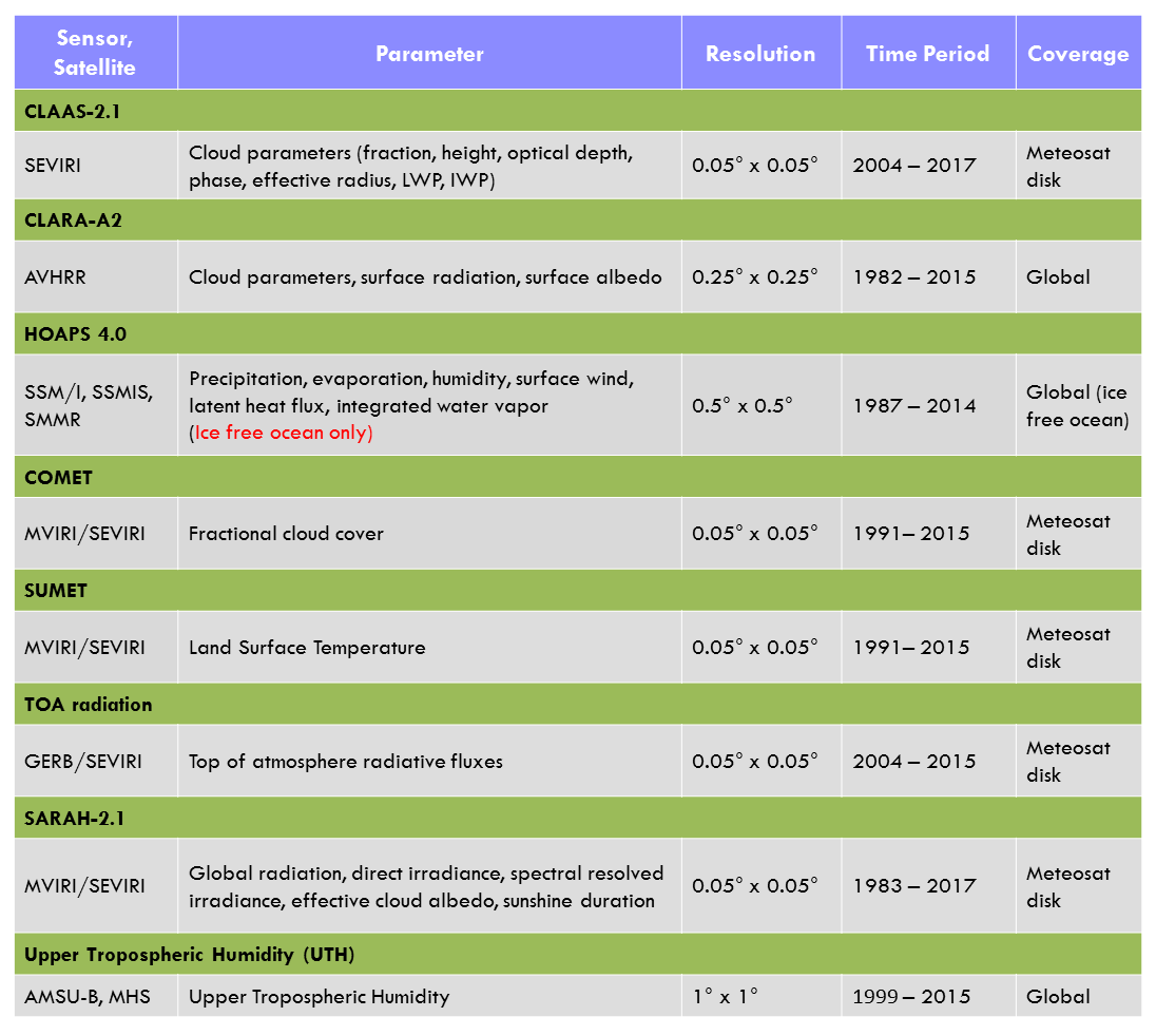
Detailed information about the CM SAF (Thematic) Climate Data Records (TCDR's). |
||
Content of this section as pdf to download Search and Order CM SAF Data |
||
| CM SAF: Data Formats, Software Tools and Installation | ||
The CM SAF R toolbox |
||
Information about tutorial |
||
| Land Surface Application SAF Data for Climate Applications | In this presentation you will learn:
To listen to the audio open the pdf, on each slide place your mouse over the |
|
In this presentation you will learn about:
|
||
| LSA SAF Data Formats & Software Tools | ||
You need to download the following files, before going through the QGIS tutorial: importa_data_reproj_MLST importa_data_reproj_MFVC importa_data_reproj_MFAPAR importa_data_reproj_MET importa_data_reproj_METREF |
||
| Atmospheric Composition SAF Data | From this section you can find basic information on NO2 and H2O and learn which kind of studies you can use the data for. |
|
In this section you will learn how to register as a user to the DLR ATMOS data service. This is needed in order to download the data. |
||
In this section you will learn how you can access the data via DLR ATMOS data service. |
||
| The Copernicus Climate Data Store | ||
| !!! Your Mini Project for the Classroom Session !!! | Some Application Examples of CM SAF Data are provided here. |
|
Crop monitoring using FAPAR |
||
Crop monitoring using FAPAR |
||
| Classroom Phase | Manual, CM SAF R Package Description, ... |
|
MSG Toolbax Manual and test tutorial |
||
Tutorials on how to prepare your Qgis environment before start working and a tutorial on how to import Qgis data into Qgis |
 button and start the audio by clicking on the play button
  .
.