Data processing and file formats
Within this book you will find two chapters. The first covers the processing that takes place to generate the data that is ultimately received by users of the CMDS. The second chapter goes in to the format of these data files, and the information that can be extracted from them.
2. Data formats and processing methodology: SLSTR
Data Levels
Within remote sensing of sea-surface temperature there are a series of levels that are used to define the amount of processing that has been performed to provide a given dataset:
-
Level 0: This step processes raw data contained in instruments source packets Level 0 products are internal products, and are not disseminated to users.
-
Level 1: This step processes the Level 0 data to geo-located radiometric measurements for each SLSTR channel/view. SLSTR Level 1 processing is divided into two main steps. Instrument grid processing (Level 1A) and image grid processing (Level 1B). The Level-1 product provides radiances and brightness temperatures for each pixel in a regular image grid, each view and each SLSTR channel, plus annotations data associated with SLSTR pixels.
-
Level 2: This step processes the Level 1 data to geophysical data (e.g. sea surface temperature, land surface temperature). It, again consists of two stages. In the first stage, SST processing to generate five single-algorithm SST products using various methods. These are provided in the Level 2 WCT product, which is not typically distributed. This is followed by a processing module, which generates a Group for High Resolution Sea Surface Temperature (GHRSST) compliant product, referred to as a Level 2 WST product, which is distributed.
Processing Methodology
SLSTR Level 1 processing is divided into two main steps (figure 2.1):
- Instrument grid processing
- Image grid processing
The instrument grid processing has five sub-steps (figure 2.1, left hand column). First the source packets from the instrument are processed. Next the data is calibrated: For the IR channels this involves calculating the calibration offset and slope that describes the linear relationship between numerical counts and radiance; for the VIS/NIR/SWIR channels, the calibration is based on a diffuse calibration (VISCAL) target of accurately known reflectance which is illuminated by the sun over a short segment of the orbit to enable a linear calibration relationship between the measured signal in each channel and the surface reflectance to be determined. Finally, the time and geolocation are calculated for each pixel.
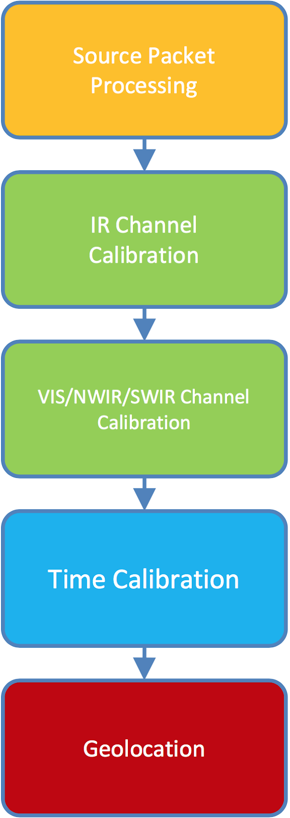
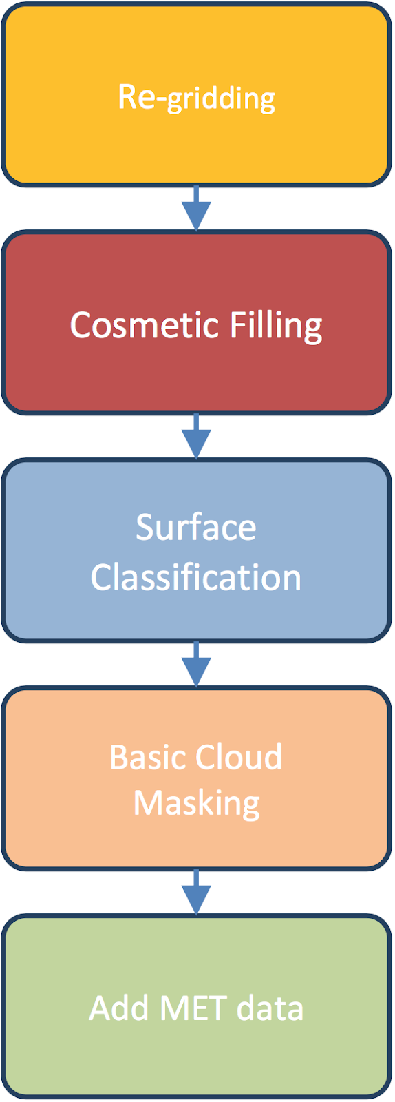
Figure 2.1; Level 1 processing stages for instrument grid processing (level 1A, left column) and image grid processing (level 1B, right column).
The image grid processing re-grids the SLSTR measurements onto the nominal raster image, and tests each pixel for cloud. It also contains five sub-steps (figure 2.1, right hand column).
In the re-gridding, the across and along track indices are calculated for each instrument pixel on either a 1 km raster image grid for the thermal IR channels or a 0.5 km grid for the visible, NIR and SWIR channels. The re-gridding is done by nearest neighbour resampling. Missing image pixels are then cosmetically filled.
The data is strictly speaking not cosmetic, i.e. it is not made up, it is simply that an instrument pixel might be used more than once. Instrument pixels that are not used in generating the image pixels are included in the orphan pixels’ containers. Surface Classification and the Basic Cloud Masking are then applied to each image pixel. Finally, the ECMWF meteorological fields are added on a sub-grid referred to as the tie-point grid.
SLSTR Level-2 marine processing includes two primary steps (figure 2.2):
- SST processing to generate five single-algorithm SST products using the method described in Section 3.5. These are provided in the Level 2 WCT product. The SSTs included are:
- 1 km N2 SST
- Nadir single view using channels S8 and S9, i.e. 10.85 and 12 μm
- 1 km N3 SST
- Nadir single view and all thermal channels (N2 plus S7, i.e. 3.7 μm)
- 1 km N3R SST
- Like N3 but using the property of "aerosol robustness" and its associated method described in [RD-5]
- 1 km D2 SST
- Like N2, except that BTs in both the oblique and nadir views are used
- 1 km D3 SST
- Like N3, except that both views are used.
- The L2P processing module, which generates a Group for High Resolution Sea Surface Temperature (GHRSST) compliant product. The L2P product contains only the best available SST for each pixel according to a set of rules define in the SLSTR Level 2 SST ATBD. In an extra step compared to the WCT product, the WST SSTs are atmospherically smoothed to reduce noise introduced in the retrieval process. Further details of the smoothing can be found in the SLSTR Level 2 SST ATBD. The L2P format data file is provided in the Level 2 WST product.
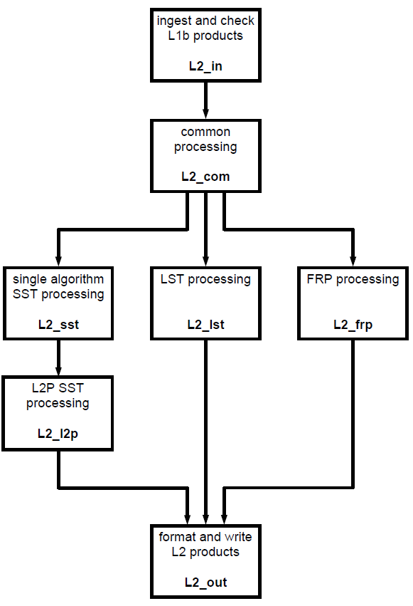
Figure 2.2; Level 2 processing stages for SLSTR.
The following products are generated at the levels described above;
Level 1 RBT
This product provides radiances and brightness temperatures for each pixel, view and channel.
Level 2 WCT (only available to Cal/Val users via S3VT)
This product provides sea surface temperature for all offered retrieval algorithms.
Level 2 WST
This product provides the best SST at each SLSTR location in GHRSST L2P format.
File Names
The file naming is based on a sequence of fields:
MMM_SS_L_TTTTTT_YYYYMMDDTHHMMSS_YYYYMMDDTHHMMSS_YYYYMMDDTHHMMSS_<instanceID><class_ID>.<extension>
Where;
-
MMM – Mission id, e.g. S3A
-
SS - Instrument e.g. SL is for SLSTR
-
L - Processing level, e.g. 1 for L1 and 2 for L2
-
TTTTT - Data Type ID, e.g.
-
“RBT___” = TOA radiances and brightness temperatures
-
“WCT___” = Retrieved SST for all algorithms
-
“WST___” = Best SST in GHRSST L2P format
-
-
YYYYMMDDTHHMMSS - 15 character Data Start time, then Data Stop time then Creation Date
-
<instance id > - 17 characters e.g. 0180_004_051_1979 is duration, cycle number, relative orbit number and frame along track coordinate GGG – Product Generating Centre e.g., EUM = EUMETSAT and SVL = Svalbard Satellite Core Ground Station
-
<class ID> - 8 characters to indicate the processing system e.g., O_NR_001 is the software platform (O for operational, F for reference, D for development and R for reprocessing), processing workflow (NR for Near Real Time, ST for Short Time Critical and NT for Non Time Critical) and 3 letters/digits indicating the baseline collection.
-
<extension> - Filename extension, SEN3
Which for Sentinel-3 SLSTR data would be, for example:
S3A_SL_1_RBT____20160509T103945_20160509T104245_20160509T124907_0180_004_051_1979_SVL_O_NR_001.SEN3
File types
Please see the ocean colour section.